
 Latest images
GUIDES TO FISHING MARKS AROUND THE UPPER BRISTOL CHANNEL FOR RESOURCE
ADDICTION ANGLING RESOURCES & INFORMATION SITE :: GOOGLE MAPS & FISHING MARKS AROUND THE UK RESOURCES LIST
Page 1 of 1
![]()
 GUIDES TO FISHING MARKS AROUND THE UPPER BRISTOL CHANNEL FOR RESOURCE
![]() by Admin Tue May 03, 2011 10:50 pm
by Admin Tue May 03, 2011 10:50 pm
Hello and welcome
Here we will be listing the fishing marks of the upper bristol channel a bit of general information on each mark, species, tactics,baits etc.
We hope you will find them a useful resource and that they give you a better insight to each mark.
We will also be building a google map of the fishing marks around the bristol channel and south west that we feel needs to be done so you can.
A/ find out how to get to the marks
B/ find marks you have not fished and where they are
This we feel will answer a lot of your questions on the marks how to fish and when,
we will also link any tackle shops that are nearby with internet links and charter boats, all this you will find here as we build it.
it will be constantly updated and new marks added and details added we hope you like the effort put in to it.
http://maps.google.com/maps/ms?ie=UTF8&hl=en&msa=0&msid=213639595381108774752.000490adddfe3a4567019&t=h&ll=50.954967,-2.757568&spn=1.840928,3.532104&z=8
WARNING PLEASE TAKE A NOTE OF THIS!!!!!
The bristol channel has the second fastest and highest rising tides in the world and the upper reaches have the longest tidal bore known as the severn bore on the biggest tides of the year.
Also most of the tidal reaches in the upper channel expose soft mud silt beds these are dangerous!!!!!
Also the upper reaches between portishead and clevedon the main fishing is done off of rock ledges although there are a few low water venues knowledge and fishing with some one who knows them is a recommended priority for safety.
Make sure you are with some one that knows the marks ensure you have safe footwear and waterproof clothing as it is along walk to most marks and they are like all coasts exposed to the elements.
Do not fish is storms or high winds as rogue waves can wash you off the marks !!!
Do not fish low water reefs unless you know them or fish them alone also ensure you have a safe retreat and keep an eye on the tide as in most places that are fished at low water the tide can come in behind you.
Also above all else make sure you tell some one where you are going and what time you expect to be back, and if night fishing ensure you have a good head light and spare batteries and a back up just in case of a fault developing.
You do not want to stumble around rock ledges and footpaths in the dark!!!!!!!
That said we hope you all enjoy the opportunity to fish these marks safely and are aware of the dangers.
Regards and tight lines all the admin team.
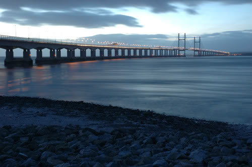
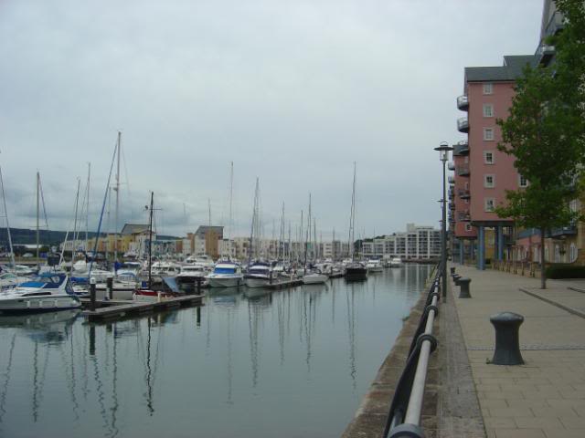
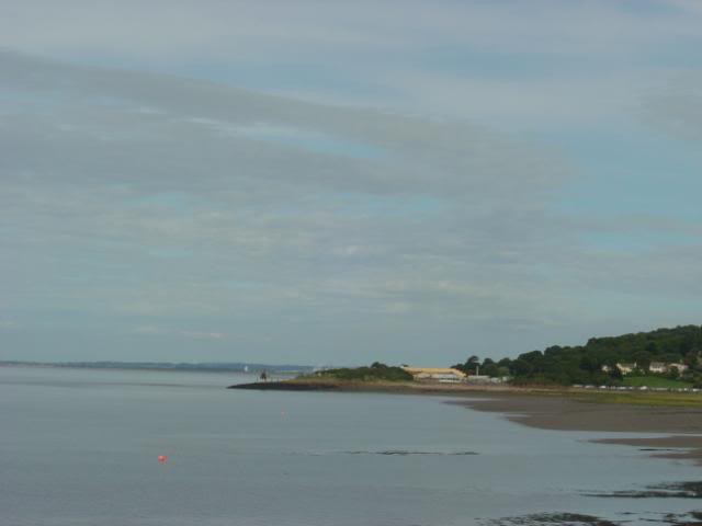
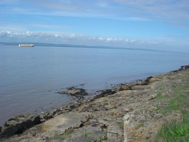
FIRST UP IS LYDNEY HARBOUR

VIEW OF THE UPPER SEVERN SOUTH FROM LYDNEY HARBOUR

LYDNEY HARBOUR WALL LOOKING SOUTH

LYDNEY HARBOUR WALL

LYDNEY HARBOUR ENTRANCE LOCK GATES

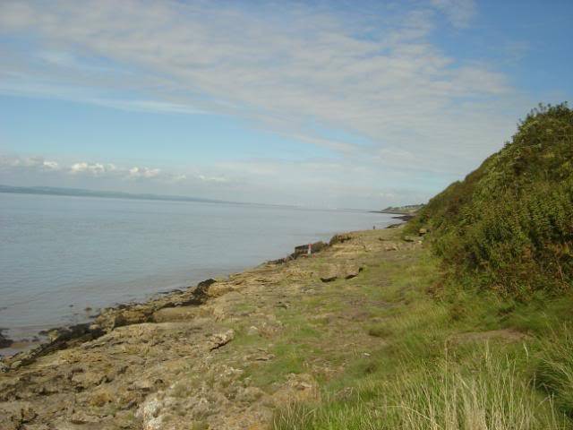
VIEW NORTH UP THE SEVERN FROM LYDNEY HARBOUR WALL

LOOKING ACROSS TOWARDS SHARPNESS DOCKS.
This is lydney harbour and coastal footpath.
YOU WILL NEED AN ENVIRONMENT ROD LICENCE HERE AS WITH ALL UPPER CHANNEL MARKS ABOVE THE SEVERN BRIDGES.
SALMON, SEA TROUT, ALLIS SHAD AND TWAITE SHAD RUN THE UPPER REACHES SO THE BAILIFFS ARE HOT UP HERE.
As these have a commercial licence and the elvering activities are very strongly monitored in the upper reaches!!!
You may be only fishing for sea species like mullet bass sole and flounder possible whiting and coddling + silver eels this is the lower reaches of the river severn and comes under the environment agency rod licence regards fishing activities.
Also the fact there are migratory species salmon,sea trout, allis and twaite shad known to frequent the upper reaches.
these are protected and all have to be released so they can proceed to their breeding grounds.
So do not be surprised to be challenged by a bailiff !!
Saltwater species can be fished for but if you land any of the above and retain it be prepared to lose your gear and be prosecuted !!!
This applies effectively from the old severn bridge crossing upwards.
But mullet flounders sole and bass can be caught here along with the odd codling and whiting and silver eels in their seasons.
2 & 3 hook scratching rigs work best up here .
baits worm baits but maddies fish better second ragworm and lugworm tipped with squid or sliver of mackerel.
best fishing big tides 2.5 hours flood and about 1/2 hr over the top and start of the ebb,
waist of time after that as the fish start to run back down the channel on the ebb and do not feed till they get to the lower reaches.
Here we will be listing the fishing marks of the upper bristol channel a bit of general information on each mark, species, tactics,baits etc.
We hope you will find them a useful resource and that they give you a better insight to each mark.
We will also be building a google map of the fishing marks around the bristol channel and south west that we feel needs to be done so you can.
A/ find out how to get to the marks
B/ find marks you have not fished and where they are
This we feel will answer a lot of your questions on the marks how to fish and when,
we will also link any tackle shops that are nearby with internet links and charter boats, all this you will find here as we build it.
it will be constantly updated and new marks added and details added we hope you like the effort put in to it.
http://maps.google.com/maps/ms?ie=UTF8&hl=en&msa=0&msid=213639595381108774752.000490adddfe3a4567019&t=h&ll=50.954967,-2.757568&spn=1.840928,3.532104&z=8
WARNING PLEASE TAKE A NOTE OF THIS!!!!!
The bristol channel has the second fastest and highest rising tides in the world and the upper reaches have the longest tidal bore known as the severn bore on the biggest tides of the year.
Also most of the tidal reaches in the upper channel expose soft mud silt beds these are dangerous!!!!!
Also the upper reaches between portishead and clevedon the main fishing is done off of rock ledges although there are a few low water venues knowledge and fishing with some one who knows them is a recommended priority for safety.
Make sure you are with some one that knows the marks ensure you have safe footwear and waterproof clothing as it is along walk to most marks and they are like all coasts exposed to the elements.
Do not fish is storms or high winds as rogue waves can wash you off the marks !!!
Do not fish low water reefs unless you know them or fish them alone also ensure you have a safe retreat and keep an eye on the tide as in most places that are fished at low water the tide can come in behind you.
Also above all else make sure you tell some one where you are going and what time you expect to be back, and if night fishing ensure you have a good head light and spare batteries and a back up just in case of a fault developing.
You do not want to stumble around rock ledges and footpaths in the dark!!!!!!!
That said we hope you all enjoy the opportunity to fish these marks safely and are aware of the dangers.
Regards and tight lines all the admin team.
FIRST UP IS LYDNEY HARBOUR
VIEW OF THE UPPER SEVERN SOUTH FROM LYDNEY HARBOUR
LYDNEY HARBOUR WALL LOOKING SOUTH
LYDNEY HARBOUR WALL
LYDNEY HARBOUR ENTRANCE LOCK GATES
VIEW NORTH UP THE SEVERN FROM LYDNEY HARBOUR WALL
LOOKING ACROSS TOWARDS SHARPNESS DOCKS.
This is lydney harbour and coastal footpath.
YOU WILL NEED AN ENVIRONMENT ROD LICENCE HERE AS WITH ALL UPPER CHANNEL MARKS ABOVE THE SEVERN BRIDGES.
SALMON, SEA TROUT, ALLIS SHAD AND TWAITE SHAD RUN THE UPPER REACHES SO THE BAILIFFS ARE HOT UP HERE.
As these have a commercial licence and the elvering activities are very strongly monitored in the upper reaches!!!
You may be only fishing for sea species like mullet bass sole and flounder possible whiting and coddling + silver eels this is the lower reaches of the river severn and comes under the environment agency rod licence regards fishing activities.
Also the fact there are migratory species salmon,sea trout, allis and twaite shad known to frequent the upper reaches.
these are protected and all have to be released so they can proceed to their breeding grounds.
So do not be surprised to be challenged by a bailiff !!
Saltwater species can be fished for but if you land any of the above and retain it be prepared to lose your gear and be prosecuted !!!
This applies effectively from the old severn bridge crossing upwards.
But mullet flounders sole and bass can be caught here along with the odd codling and whiting and silver eels in their seasons.
2 & 3 hook scratching rigs work best up here .
baits worm baits but maddies fish better second ragworm and lugworm tipped with squid or sliver of mackerel.
best fishing big tides 2.5 hours flood and about 1/2 hr over the top and start of the ebb,
waist of time after that as the fish start to run back down the channel on the ebb and do not feed till they get to the lower reaches.
Last edited by Admin on Wed Jul 27, 2011 11:07 am; edited 1 time in total
Admin- Admin Team

- Posts : 440
Join date : 2010-06-21 -

![]()
![]()
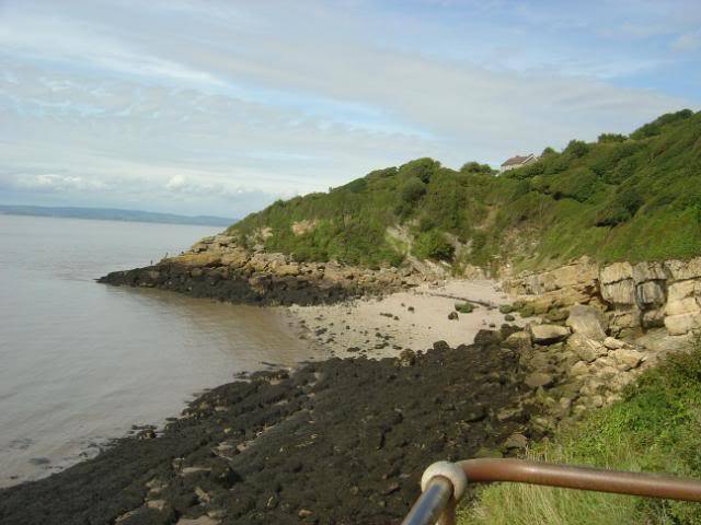
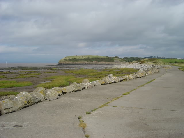
AUST REDWICK & NEW PASSAGE
![]() by Admin Tue May 03, 2011 10:53 pm
by Admin Tue May 03, 2011 10:53 pm
Hello here we have a couple of fishing marks from aust to redwick sea wall in the upper bristol channel.
FROM AUST TO REDWICK

AUST PEAT LEDGES

LOOKING ACROSS TO CHEPSTOW FROM AUST
This is aust very popular with veals as they hold a lot of matches here.
It is very muddy here so be prepared its best to fish mid spring tides up but avoid the biggest tides as they come over the grass banks!!
Fishing about depending on tides 2 hrs flood tide and 2 hrs ebb tide
Species codling,flounder,sole, silver eels,mullet, strap congers.and odd bass.
BUT!!!!!
Make a note to much rain and flood waters and snow melts, means loads of freshwater coming down the severn and its tributaries which means because of the shallow nature of the upper channel marks salinity levels will drop and saltwater species will lay off in the deeper channels!!!!
Fishing can and will be poor in or after these conditions till the salt levels increase and the food stuff moves back then the fish will be back.

NEW PASSAGE AND AUST VIEWED FROM REDWICK WALL
New passage is again grass peat ledges and runs from redwick to aust again fishing is the same as aust but be prepared for a bit of a walk best accessed from redwick.
Popular for sole fishing along here august to october.
Be warned same as aust the biggest tides come over the grass banks!!

ANOTHER VIEW FROM THE OLD RAILWAY PIER

VIEW FROM REDWICK WALL

REDWICK WALL VIEWED FROM THE OLD RAILWAY PIER .

MEMORIAL PLAQUE MARKING THE PIER AT REDWICK
EVENING TIDE INCOMING AT REDWICK

VIEW NORTH ALONG NEW PASSAGE AND REDWICK SEA WALLS.
Fishing from redwick sea wall that runs from redwick to severn beach.
There are several access points for the wall redwick, shaft road, and beach road severn beach.
There are several deeper water points along here so a walk along its length is recommended
these will also give you and advantage of a little more fishing time.
Fishing much the same along along here as aust and new passage but longer fishing times.
Some points along the wall will allow neap tide fishing but mid spring tides to the biggest spring tides best, but expect a strong tidal pull through this length of the channel!!
Depending on tides and winds fishing over high water dependant on location can be approx 3 hours up and 2 hours down max but as a rule 2.5 up and 2 back.
Species codling, mullet, bass, conger, sole, in their seasons but expect the odd small smooth hound and dogfish and pout as the odd summer visitor agian dependant of the lack of freshwater flushing down the channel .
Tactics 2-3 hook scratching rigs for general fishing but 2/0 -4/0 pulley pennel or dropper rigs for the bass, strap conger. and codling.
Baits worm baits and crab baits or cocktail baits work well depending on season and fish targeted.
The same tactics apply in general all along here from aust to avonmouth
A hint here is to fish close in as the fish run the tidal edges out of the strong currents to feed most fish are caught close in some at distance but be prepared for a strong tidal pull at distance.
Check out the google map here.
http://maps.google.com/maps/ms?ie=UTF8&hl=en&msa=0&msid=213639595381108774752.000490adddfe3a4567019&t=h&ll=50.954967,-2.757568&spn=1.840928,3.532104&z=8
FROM AUST TO REDWICK
AUST PEAT LEDGES
LOOKING ACROSS TO CHEPSTOW FROM AUST
This is aust very popular with veals as they hold a lot of matches here.
It is very muddy here so be prepared its best to fish mid spring tides up but avoid the biggest tides as they come over the grass banks!!
Fishing about depending on tides 2 hrs flood tide and 2 hrs ebb tide
Species codling,flounder,sole, silver eels,mullet, strap congers.and odd bass.
BUT!!!!!
Make a note to much rain and flood waters and snow melts, means loads of freshwater coming down the severn and its tributaries which means because of the shallow nature of the upper channel marks salinity levels will drop and saltwater species will lay off in the deeper channels!!!!
Fishing can and will be poor in or after these conditions till the salt levels increase and the food stuff moves back then the fish will be back.
NEW PASSAGE AND AUST VIEWED FROM REDWICK WALL
New passage is again grass peat ledges and runs from redwick to aust again fishing is the same as aust but be prepared for a bit of a walk best accessed from redwick.
Popular for sole fishing along here august to october.
Be warned same as aust the biggest tides come over the grass banks!!
ANOTHER VIEW FROM THE OLD RAILWAY PIER
VIEW FROM REDWICK WALL
REDWICK WALL VIEWED FROM THE OLD RAILWAY PIER .
MEMORIAL PLAQUE MARKING THE PIER AT REDWICK
EVENING TIDE INCOMING AT REDWICK
VIEW NORTH ALONG NEW PASSAGE AND REDWICK SEA WALLS.
Fishing from redwick sea wall that runs from redwick to severn beach.
There are several access points for the wall redwick, shaft road, and beach road severn beach.
There are several deeper water points along here so a walk along its length is recommended
these will also give you and advantage of a little more fishing time.
Fishing much the same along along here as aust and new passage but longer fishing times.
Some points along the wall will allow neap tide fishing but mid spring tides to the biggest spring tides best, but expect a strong tidal pull through this length of the channel!!
Depending on tides and winds fishing over high water dependant on location can be approx 3 hours up and 2 hours down max but as a rule 2.5 up and 2 back.
Species codling, mullet, bass, conger, sole, in their seasons but expect the odd small smooth hound and dogfish and pout as the odd summer visitor agian dependant of the lack of freshwater flushing down the channel .
Tactics 2-3 hook scratching rigs for general fishing but 2/0 -4/0 pulley pennel or dropper rigs for the bass, strap conger. and codling.
Baits worm baits and crab baits or cocktail baits work well depending on season and fish targeted.
The same tactics apply in general all along here from aust to avonmouth
A hint here is to fish close in as the fish run the tidal edges out of the strong currents to feed most fish are caught close in some at distance but be prepared for a strong tidal pull at distance.
Check out the google map here.
http://maps.google.com/maps/ms?ie=UTF8&hl=en&msa=0&msid=213639595381108774752.000490adddfe3a4567019&t=h&ll=50.954967,-2.757568&spn=1.840928,3.532104&z=8
Admin- Admin Team
- Posts : 440
Join date : 2010-06-21 -
![]()
![]()
SEVERN BEACH TO AVONMOUTH + A FEW ARIAL VEIWS OF THE DOCKS
![]() by Admin Tue May 03, 2011 10:54 pm
by Admin Tue May 03, 2011 10:54 pm
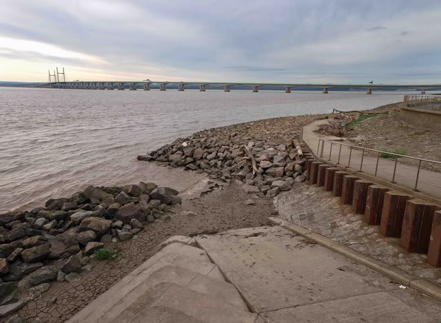
Severn beach to avonmouth.
First up is severn beach here we have the end of the severn beach to redwick sea wall that ends at the severn beach slipway.
This also marks the start of the old severn beach sea front sea wall that has steps at the bottom and a splash wall on top topped off with railings.
This then ends at the avonmouth end and becomes a salt marsh backed up with an earth bank as a sea defence that runs to avonmouth, here it is replaced with the port authority sea defence walls and piers.
Severn beach sea wall.
ABOVE THE SEA WALL STEPS SEVERN BEACH
THE SLIPWAY SEVERN BEACH

THE FORESHORE FROM THE OPPOSITE END OF THE SEA WALL AT SEVERN BEACH

A LOOK ALONG THE SEA WALL SEVERN BEACH TOWARDS AVONMOUTH
As you can see from the photos here what you are fishing over is mud flats and broken ground with a littering of drainage pipes dotted along the beach.
best fishing is spring tides high water depending on tide and winds a westerly pushes it in quicker and holds it back longer.
You get approx 2- 2.5 hrs flood and 1.5 to 2 hrs ebb tide if you decide to fish the incoming tide from below the wall till you have to go up or 1.5-2.hours flood 1-1.5 hours ebb depending on tides and winds.
In their seasons codling ,flounder, bass. whiting, sole,conger, mullet and odd bass.
But expect the odd surprise visitor if the freshwater flushing from the rivers has been reduced by long hot dry spells. maybe a small smooth hound and odd dogfish and pout.
Tactics same as redwick sea wall close in shorter casts sorts the fish out but they can be caught at distance but the tidal pull will be strong!!
Also if the rivers are flushing loads of freshwater weed can be a big problem wrapping round the lines.
2-3 hook scratching rigs for the smaller species and pulley pennel rigs and dropper rigs 2/0-4/0 hooks for the coddling bass and congers.
The peat ledges of crooks marsh severn beach to avonmouth.
The salt marshes between severn beach and avonmouth or severside as they are often referred to as are called crooks marsh.
It consists of grassy peat ledges that open up onto mud flats there are a few access points with parking in the many layby parking along severside road with foot paths over or under the railway line.
like aust and new passage the biggest tides come over the ledges and flood the grass banks along with the mud channels that get filled with water so best avoid on the biggest tides
Best on mid spring tides fishing approx 2 hrs flood 2 hrs ebb dependant on tides and winds
species bass, codling, flounder ,sole, mullet and silver eels
tactics same as severn beach.

THE PEAT LEDGES AT SEVERSIDE LOOKING TOWARDS SEVERN BEACH

THE PEAT LEDGES AT SEVERNSIDE LOOKING TOWARDS AVONMOUTH AND ROCKINGHAM SEA WALL
Tactics and baits the same as severn beach.
Here we have found a few aerial photos of the docks area of avonmouth and royal portbury docks.
This also gives you a good view of the upper bristol channel and also the fishing potential we can not have from some interesting points off the dock walls.
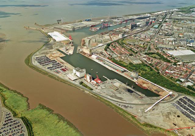
AERIAL PICTURE OF AVONMOUTH DOCKS AND THE RIVER AVON

AERIAL VIEW OF BOTH PORTBURY AND AVONMOUTH DOCKS LOOKING UP THE SEVERN TO AND PAST THE BRIDGES

AERIAL VEIW OF ROYAL PORTBURY DOCKS AND A PEEK UP THE AVON PAST PILL.
Check out our google map of the fishing marks in the bristol channel here
http://maps.google.com/maps/ms?ie=UTF8&hl=en&msa=0&msid=213639595381108774752.000490adddfe3a4567019&t=h&ll=50.954967,-2.757568&spn=1.840928,3.532104&z=8
First up is severn beach here we have the end of the severn beach to redwick sea wall that ends at the severn beach slipway.
This also marks the start of the old severn beach sea front sea wall that has steps at the bottom and a splash wall on top topped off with railings.
This then ends at the avonmouth end and becomes a salt marsh backed up with an earth bank as a sea defence that runs to avonmouth, here it is replaced with the port authority sea defence walls and piers.
Severn beach sea wall.
ABOVE THE SEA WALL STEPS SEVERN BEACH
THE SLIPWAY SEVERN BEACH
THE FORESHORE FROM THE OPPOSITE END OF THE SEA WALL AT SEVERN BEACH
A LOOK ALONG THE SEA WALL SEVERN BEACH TOWARDS AVONMOUTH
As you can see from the photos here what you are fishing over is mud flats and broken ground with a littering of drainage pipes dotted along the beach.
best fishing is spring tides high water depending on tide and winds a westerly pushes it in quicker and holds it back longer.
You get approx 2- 2.5 hrs flood and 1.5 to 2 hrs ebb tide if you decide to fish the incoming tide from below the wall till you have to go up or 1.5-2.hours flood 1-1.5 hours ebb depending on tides and winds.
In their seasons codling ,flounder, bass. whiting, sole,conger, mullet and odd bass.
But expect the odd surprise visitor if the freshwater flushing from the rivers has been reduced by long hot dry spells. maybe a small smooth hound and odd dogfish and pout.
Tactics same as redwick sea wall close in shorter casts sorts the fish out but they can be caught at distance but the tidal pull will be strong!!
Also if the rivers are flushing loads of freshwater weed can be a big problem wrapping round the lines.
2-3 hook scratching rigs for the smaller species and pulley pennel rigs and dropper rigs 2/0-4/0 hooks for the coddling bass and congers.
The peat ledges of crooks marsh severn beach to avonmouth.
The salt marshes between severn beach and avonmouth or severside as they are often referred to as are called crooks marsh.
It consists of grassy peat ledges that open up onto mud flats there are a few access points with parking in the many layby parking along severside road with foot paths over or under the railway line.
like aust and new passage the biggest tides come over the ledges and flood the grass banks along with the mud channels that get filled with water so best avoid on the biggest tides
Best on mid spring tides fishing approx 2 hrs flood 2 hrs ebb dependant on tides and winds
species bass, codling, flounder ,sole, mullet and silver eels
tactics same as severn beach.
THE PEAT LEDGES AT SEVERSIDE LOOKING TOWARDS SEVERN BEACH
THE PEAT LEDGES AT SEVERNSIDE LOOKING TOWARDS AVONMOUTH AND ROCKINGHAM SEA WALL
Tactics and baits the same as severn beach.
Here we have found a few aerial photos of the docks area of avonmouth and royal portbury docks.
This also gives you a good view of the upper bristol channel and also the fishing potential we can not have from some interesting points off the dock walls.
AERIAL PICTURE OF AVONMOUTH DOCKS AND THE RIVER AVON
AERIAL VIEW OF BOTH PORTBURY AND AVONMOUTH DOCKS LOOKING UP THE SEVERN TO AND PAST THE BRIDGES
AERIAL VEIW OF ROYAL PORTBURY DOCKS AND A PEEK UP THE AVON PAST PILL.
Check out our google map of the fishing marks in the bristol channel here
http://maps.google.com/maps/ms?ie=UTF8&hl=en&msa=0&msid=213639595381108774752.000490adddfe3a4567019&t=h&ll=50.954967,-2.757568&spn=1.840928,3.532104&z=8
Last edited by Admin on Mon Sep 19, 2011 6:55 am; edited 1 time in total
Admin- Admin Team
- Posts : 440
Join date : 2010-06-21 -
![]()
![]()
PORTISHEAD QUAYS MARINA & BATTERY POINT +CHARTER BOAT LIST
![]() by Admin Tue May 03, 2011 10:56 pm
by Admin Tue May 03, 2011 10:56 pm
Continuing down the bristol channel past the busy ports of avonmouth and royal portbury docks we come main part of the popular marks of the upper bristol channel.
But first we will look at the new fishing potential on offer from a former port the port of portishead now know as portishead quays marina.
This former port is now a very busy marina and there is now several charter boats operating from here so here is another chance to fish marks that until now were the domain on the private small boats, now you can share is this good upper channel fishing potential from a charter boat.
Now for the shore angler there is loads of potential to fish what was until now what was regarded as a no fishing zone between portishead and avonmouth now you have the fishing potential of portbury wharf available now this looks like it can be another severn beach aust type venue with a good potential for flounder, mullet, odd bass, sole, and possible whiting and codling potential to the roving angler.
Peat ledges backed by grass that like severnside can on the biggest tides be covered but up to mid springs should give some interesting potential.
SO KEEPING AN OPEN MIND THERE IS NEW POTENTIAL TO BE HAD HERE.

Above is a photo of this potential that can be accessed from the marina car park that is free parking at time of posting!!!!!
As you can see a bit of walk but may be well worth it, also you have the opportunity for some sheltered fishing from the strong westerly winds off the docks sea wall here but give way to other marina users they have right of way.

Above is a photo taken from the portbury side of the lock gates looking at what is known as the steamer pier that protects the entrance on the portishead side of the locks.
Also a good veiw up the channel towards the bridges and severn beach

Above is another photo of portbury wharf taken from the portishead side of the lock gates shows the potential to be had here this was taken on a neap high tide !!
Here is a nice photo of the marina itself a very nice transformation of the old port.
Nice fishy potential for mullet and bass on the float maybe a few bottom fish to be had to as they leave the lock gates open over the higher spring tides to fill the marina so some could well be trapped in here.
You can also fish the steamer pier but not on the biggest tides as it gets covered by the biggest tides again do not fish the lock side of the pier as the marina users ( i.e. boat traffic) so do not hinder them or this mark will be lost!!!
The marina has a tackle shop reel fun fishing
http://www.reelfunfishing.co.uk/store/
Charter boats operating out of here are as follows
http://www.bristol-channel-charters.co.uk/
http://www.portisheadcharters.co.uk/
http://www.ospreycharter.com/
Now we go into the big fish territory of battery point and woodlands bay.
A note to make here is the further back along from the point the cleaner the ground you cast over and less of a tidal rip on the smaller tides.

Above is a photo taken from the mark known as the shelter a former gun emplacement behind the swimming pool portishead back along from battery point itself .
This reveals a sand bar and mud flats towards the steamer jetty along wood lands bay at big spring tide low water.
Another photo taken from the shelter toward the point there are a lot of rock ledges you can fish along here.
This is a big fish venue the angling papers would have you believe it was once but not been up to that lately but can throw its fair share of double figure cod and rays along with congers through the seasons .
A big bait big fish tactics work here a whole bluey of a couple of squid or a mackerel flapper sorts the big boys out, the strong currents that run here soon wash out skimpy small baits so big hooks big baits here onwards is the rule not the norm.

Above another photo taken from the point looking back along the ledges towards the shelter and woodlands bay.
There is a low water mark along towards woodland bay a sand bar exposes but do not fish it unless you know it or fish with some one who does know it.
Potential for some good sole rays and cod with odd bass in their seasons.
Above is a photo taken from the back of the point being a calm tide this photo shows the currents or tidal rip very well.
Fishing all along here and the point is best neap tides to mid spring tides high water you will not hold bottom on the bigger tides plus you can get washed off the ledges on the biggest tides by rogue waves and the backwash of passing boats!!!

The point itself has loads of ledges to fish from but you must expect tackle losses and fish to the rocks below a good strong rod and reel with a fast retrieve is required to bully the fish and winch them up over the snags or else they dive for the rocks and you part company.
Above is a picture from my album that shows the point under the top of a big spring tide another reason not to fish it on big tides no room left.

Another photo cant beat a nice sunset says it all.

Above is a photo of the south side ledges at the end of battery point these allow you to fish the inside line into woodlands bay also allow you you to fish the inside line of the point.
A good mark to fish the ebb as the backwash swirls the food stuff around in the eddy so the fish are more than likely to feed better on this side on the ebb .
The end puts you into a deep water channel and on big spring tides a steep shelving sandbar appears that runs nearly to sugar loaf bay.
This shows the deep water channel worth a good look on big spring lows to get some casting bearings.
Potential for a bit of light fishing for potential bass and flounder and sole by casting into the bay over the mud flats with 2-3 hook scratching rigs ,

Above is a photo taken from the path that goes past the swimming pool to the steps that lead you out over the top towards the point.
This shows the south side ledges that also gives you an idea of the fishing potential as this was taken on a very low neap tide.

Above is another photo taken looking across woodland bay towards sugar loaf bay in the distance where the portishead sailing club is based, taken on a small neap tide.
Above is a reverse photo of battery point across woodlands bay taken from sugar loaf bay.
That about covers battery point and woodlands bay plus the new fishing potential of portishead quays marina.
Main tactics for this mark is pulley pennel rigs and dropper rigs big hooks 4/0 -8/0 big baits for the better fish.
Strong tides mean strong hook lengths 40lb + big baits mackerel flapper fillets of mackerel or bluey that seems to be the bait of preference at the time of posting.
Best fishing times are about 2.5 hours flood and dependant on tides and winds about 1/2/hr-1 hour on the ebb after that the currents will be to strong to effectively hold bottom to fish it and they will sweep your tackle into the reefs at the bottom,
tackle losses can be high then again dependant where you fish you may get lucky and not lose any!!
The end of the point fishing into woodlands bay can give you a better chance to fish the ebb tides down to low the smallest tides best aprox 3 hrs ebb and 2 hrs flood.
Large baits of lugworm ragworm squid mackerel bluey cocktails and 2-3 large peelers in spring summer. small baits get washed out quick and regular re-baiting will give you the best chance of a good fish, ( small stingy baits wont get you much if anything that is if its still on the hook when it hits bottom) !!!
Species cod ( better chance of a double here the odd one still show) codling rays ( again some good potential for that double here) odd sole odd smooth hound in their seasons, flounder, odd bass, whiting. dogfish. pout and some good congers ( again potential for a double is high )
Expect tackle losses more so on the point itself and beware the wash of the shipping that passes past here and rogue waves do not fish alone and fish with some one who knows the mark.
Remember good footwear waterproof and wind proof clothing and if fishing after dark a good head light a spare and do not forget some spare batteries.!!!
Like all bristol channel and other marks this can be very exposed to the elements beware be safe!!
Check out our google maps for more information here
http://maps.google.com/maps/ms?ie=UTF8&hl=en&msa=0&msid=213639595381108774752.000490adddfe3a4567019&t=h&ll=50.954967,-2.757568&spn=1.840928,3.532104&z=8
But first we will look at the new fishing potential on offer from a former port the port of portishead now know as portishead quays marina.
This former port is now a very busy marina and there is now several charter boats operating from here so here is another chance to fish marks that until now were the domain on the private small boats, now you can share is this good upper channel fishing potential from a charter boat.
Now for the shore angler there is loads of potential to fish what was until now what was regarded as a no fishing zone between portishead and avonmouth now you have the fishing potential of portbury wharf available now this looks like it can be another severn beach aust type venue with a good potential for flounder, mullet, odd bass, sole, and possible whiting and codling potential to the roving angler.
Peat ledges backed by grass that like severnside can on the biggest tides be covered but up to mid springs should give some interesting potential.
SO KEEPING AN OPEN MIND THERE IS NEW POTENTIAL TO BE HAD HERE.
Above is a photo of this potential that can be accessed from the marina car park that is free parking at time of posting!!!!!
As you can see a bit of walk but may be well worth it, also you have the opportunity for some sheltered fishing from the strong westerly winds off the docks sea wall here but give way to other marina users they have right of way.
Above is a photo taken from the portbury side of the lock gates looking at what is known as the steamer pier that protects the entrance on the portishead side of the locks.
Also a good veiw up the channel towards the bridges and severn beach
Above is another photo of portbury wharf taken from the portishead side of the lock gates shows the potential to be had here this was taken on a neap high tide !!
Here is a nice photo of the marina itself a very nice transformation of the old port.
Nice fishy potential for mullet and bass on the float maybe a few bottom fish to be had to as they leave the lock gates open over the higher spring tides to fill the marina so some could well be trapped in here.
You can also fish the steamer pier but not on the biggest tides as it gets covered by the biggest tides again do not fish the lock side of the pier as the marina users ( i.e. boat traffic) so do not hinder them or this mark will be lost!!!
The marina has a tackle shop reel fun fishing
http://www.reelfunfishing.co.uk/store/
Charter boats operating out of here are as follows
http://www.bristol-channel-charters.co.uk/
http://www.portisheadcharters.co.uk/
http://www.ospreycharter.com/
Now we go into the big fish territory of battery point and woodlands bay.
A note to make here is the further back along from the point the cleaner the ground you cast over and less of a tidal rip on the smaller tides.
Above is a photo taken from the mark known as the shelter a former gun emplacement behind the swimming pool portishead back along from battery point itself .
This reveals a sand bar and mud flats towards the steamer jetty along wood lands bay at big spring tide low water.
Another photo taken from the shelter toward the point there are a lot of rock ledges you can fish along here.
This is a big fish venue the angling papers would have you believe it was once but not been up to that lately but can throw its fair share of double figure cod and rays along with congers through the seasons .
A big bait big fish tactics work here a whole bluey of a couple of squid or a mackerel flapper sorts the big boys out, the strong currents that run here soon wash out skimpy small baits so big hooks big baits here onwards is the rule not the norm.
Above another photo taken from the point looking back along the ledges towards the shelter and woodlands bay.
There is a low water mark along towards woodland bay a sand bar exposes but do not fish it unless you know it or fish with some one who does know it.
Potential for some good sole rays and cod with odd bass in their seasons.
Above is a photo taken from the back of the point being a calm tide this photo shows the currents or tidal rip very well.
Fishing all along here and the point is best neap tides to mid spring tides high water you will not hold bottom on the bigger tides plus you can get washed off the ledges on the biggest tides by rogue waves and the backwash of passing boats!!!
The point itself has loads of ledges to fish from but you must expect tackle losses and fish to the rocks below a good strong rod and reel with a fast retrieve is required to bully the fish and winch them up over the snags or else they dive for the rocks and you part company.
Above is a picture from my album that shows the point under the top of a big spring tide another reason not to fish it on big tides no room left.
Another photo cant beat a nice sunset says it all.
Above is a photo of the south side ledges at the end of battery point these allow you to fish the inside line into woodlands bay also allow you you to fish the inside line of the point.
A good mark to fish the ebb as the backwash swirls the food stuff around in the eddy so the fish are more than likely to feed better on this side on the ebb .
The end puts you into a deep water channel and on big spring tides a steep shelving sandbar appears that runs nearly to sugar loaf bay.
This shows the deep water channel worth a good look on big spring lows to get some casting bearings.
Potential for a bit of light fishing for potential bass and flounder and sole by casting into the bay over the mud flats with 2-3 hook scratching rigs ,
Above is a photo taken from the path that goes past the swimming pool to the steps that lead you out over the top towards the point.
This shows the south side ledges that also gives you an idea of the fishing potential as this was taken on a very low neap tide.
Above is another photo taken looking across woodland bay towards sugar loaf bay in the distance where the portishead sailing club is based, taken on a small neap tide.
Above is a reverse photo of battery point across woodlands bay taken from sugar loaf bay.
That about covers battery point and woodlands bay plus the new fishing potential of portishead quays marina.
Main tactics for this mark is pulley pennel rigs and dropper rigs big hooks 4/0 -8/0 big baits for the better fish.
Strong tides mean strong hook lengths 40lb + big baits mackerel flapper fillets of mackerel or bluey that seems to be the bait of preference at the time of posting.
Best fishing times are about 2.5 hours flood and dependant on tides and winds about 1/2/hr-1 hour on the ebb after that the currents will be to strong to effectively hold bottom to fish it and they will sweep your tackle into the reefs at the bottom,
tackle losses can be high then again dependant where you fish you may get lucky and not lose any!!
The end of the point fishing into woodlands bay can give you a better chance to fish the ebb tides down to low the smallest tides best aprox 3 hrs ebb and 2 hrs flood.
Large baits of lugworm ragworm squid mackerel bluey cocktails and 2-3 large peelers in spring summer. small baits get washed out quick and regular re-baiting will give you the best chance of a good fish, ( small stingy baits wont get you much if anything that is if its still on the hook when it hits bottom) !!!
Species cod ( better chance of a double here the odd one still show) codling rays ( again some good potential for that double here) odd sole odd smooth hound in their seasons, flounder, odd bass, whiting. dogfish. pout and some good congers ( again potential for a double is high )
Expect tackle losses more so on the point itself and beware the wash of the shipping that passes past here and rogue waves do not fish alone and fish with some one who knows the mark.
Remember good footwear waterproof and wind proof clothing and if fishing after dark a good head light a spare and do not forget some spare batteries.!!!
Like all bristol channel and other marks this can be very exposed to the elements beware be safe!!
Check out our google maps for more information here
http://maps.google.com/maps/ms?ie=UTF8&hl=en&msa=0&msid=213639595381108774752.000490adddfe3a4567019&t=h&ll=50.954967,-2.757568&spn=1.840928,3.532104&z=8
Last edited by Admin on Tue May 03, 2011 11:07 pm; edited 1 time in total
Admin- Admin Team
- Posts : 440
Join date : 2010-06-21 -
![]()
![]()
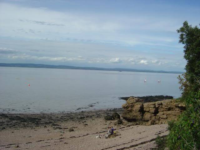
SUGAR LOAF BAY PORTISHEAD TO LADYE BAY CLEVEDON
![]() by Admin Tue May 03, 2011 10:57 pm
by Admin Tue May 03, 2011 10:57 pm
Here we carry on southwards from portishead sugarloaf bay to clevedon ladye bay, along about 4 miles of coastal footpath that runs from lady bay clevedon to woodhill bay portishead.
There are many high water and low water marks along here, but access and parking is limited to residential roads caravan parks ( if you have a friend relative living there) all will involve along walk to most marks so be prepared.
Apart from that drawback this stretch of coastline is very popular with the cod boys so in season the limited parking can be at a premium bearing in mind on weekends it will be busy and in fair weather the ramblers and dog walkers will also be vying for the parking spaces.
There are many small bays between portishead and clevedon from portishead we have woodhill bay. sugarloaf bay, redcliffe bay, walton bay, pigeon hole bay,st margarets bay. and lady bay.
St margarets bay is very often miss named lady bay ledges!!!
If you check out the ordinance survey maps you will find this in fact st margarets bay
All along here to clevedon you will be fishing a majority of the time over rough ground and from ledges for high water fishing.
The fishing times will vary depending where you fish and height of tides but for high water fishing expect about 2.5-3 hrs flood and 1.5 -2 hrs ebb, on the low water marks/reefs/sandbars expect a possible 2.5-3 hrs ebb and 1.5-2 hrs flood.
As stated mostly over rough ground so expect tackle losses!!!!
A note of warning please remember most of the venues will have rock ledges to fish of for high water fishing.
But all have a steep drop off or 20-30 ft cliff drop off most have a stepped ledges but all are covered in bladder wrack seaweed so it will be a slippery descent to access the low water marks.
There are a few safer access points but these are often taken by those in the know. other than that some of the low water reefs can be accessed but it will be a muddy and awkward to navigate !!!
We strongly recommend that you take the opportunity to walk the coastal footpath on a nice summers day on a big spring tide low water to find them and take someone who knows them and how to fish them.
Do not attempt them if you have never tried them and remember to ensure you keep an eye on the tide and have a safe retreat!!!
That said ladye bay st margarets bay and part of walton bay the low water fishing is from sandbars that are exposed on the biggest tides over low water.
A final reminder warning this applies to all the marks along this stretch of coast line!!
Some of the ledges are exposed and get covered by the highest tides rogue waves and wash from shipping will at least get you wet or at worse wash you off or your gear.
All require a good walk ensure you have everything you need, warm clothing water proofs good footwear and a good headlight and spare + batteries in case it gets dark or for fishing after dark.
Do not forget the flask of hot drink.
And last but not least check the WEATHER/WINDS
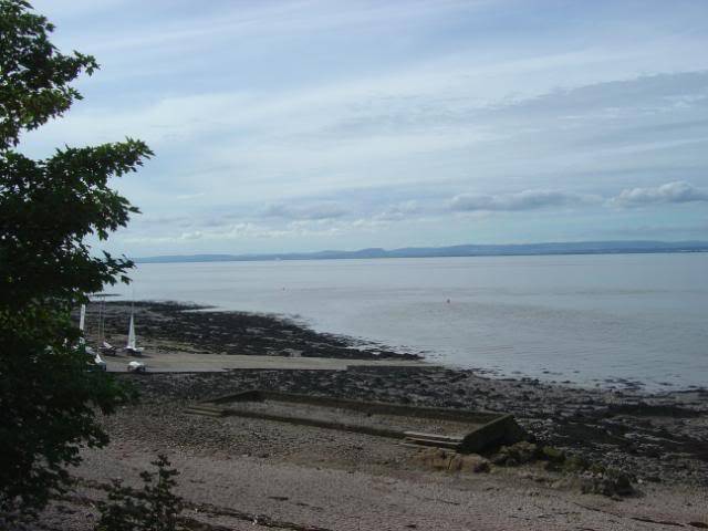
RIGHT HERE WE GO FIRST UP SUGARLOAF BAY PORTISHEAD

Above a photo looking back towards battery point across woodhill bay

above a photo of the old diving platforms at sugarloaf bay

Above a photo looking across sugar loaf bay showing the slipway and the reefs to the left of it
Above a photo looking back to the right of sugar loaf bay showing the old diving platforms and a low water reef exposing
Above another photo of the slipway and old paddling pool
Sugar loaf bay is the home of the portishead sailing club and the inshore rescue boat so remember this if you decide to fish the slipway they have priority not you!!
This is a good sheltered venue out of a s/w wind the slipway gives easy access fishing also gives better access to the low water reefs on the left of the slip way.
Fishing times high water mid springs best as the bigger tides push right in approx 2 hrs each side of high depending on tides and wind.
The low water reefs to the left bigger spring tide lows 3 hrs ebb 2 hrs flood approx depending again on tides and winds.
The low water fishing offers the best potential on this mark.
Species odd cod, codling, odd bass. congers. odd sole. dogfish.pout. silver eels. odd rays.
Tactics pulley pennell rigs or dropper rigs for the rays .congers.cod.codling bass mostly over low water.
2-3 hook scratching rigs for the smaller species over high.
Baits bluey whole squid crab mackerel for the bigger species and worm cocktails for the smaller species.
REDCLIFFE BAY PORTISHEAD

Above a photo showing the exposing low water reefs at redcliff bay

Above another photo of redcliffe bay looking towards st margarets bay clevedon in the distance.
Mostly low water reef fishing along here but there are a few high water fishing points best being black nore light about 10 minutes walk back towards portishead from here.
the low water reefs puts you with and easy cast into deep water channels mostly over sand bars but expected tackle losses and do not fish them unless you are with some one that knows them or attempt to fish them alone.
Low water reefs give about 3hrs ebb and 2 hrs flood fishing times depending on tides and winds.
Species cod.codling.congers,rays dogfish pout.odd bass and odd smooth hounds in their seasons.
Tactics big baits pulley or dropper rigs and expect tackle losses!!
ST MARGARETS BAY LOOKING AT WALTON AND PIGEON HOLE BAYS
Above is a photo showing the end of st margarets bay ledges looking at pigeon hole bay and towards walton bay under the coastguard station lookout.
Both of these venues are about 10 and 25 minutes walk further along the footpath.
The lighthouse in the distance is black nore light the piont seperates sugar loaf bay and redcliffe bay in the distance, note how close the severn bridges seem to appear.
Above is a photo of st margarets bay ladges often mistakenly referred to by anglers and angling magazines as lady bay ledges.
Above is a photo of start of st margarets bay ledges again mistakenly referred to as lady bay ledges.
you are mostly fishing over a sand bar within easy casting over high water but expect tackle losses on the lower ledges rock outcrops, also there are a few safer ways down to the low water marks on the sand bar for fishing low water spring tides.
FIRST POINT AND LADYE BAY

Above is a photo of the most popular mark know as first point this is the point that divides ladye bay in the foreground and st margarets bay behind it.
As you can see from the photo popular with local anglers but very steep and very big rock formations to swing your fish over although with extreme caution you can get to the low water ledges but they are very slippery.
Do not fish this point alone and fish with some one who knows it, AND IF YOU SUFFER VERTIGO DO NOT ATTEMPT IT !!
This mark is often the one that will through up the big cod that gets reported in the angling magazines, and is often protected by stated caught from lady bay ledges you can see why.
It is not for the novice angler!!
Above is a photo of lady bay itself, this is the bay on which above it is the road you will more than likely park your car for the main access to most of the marks along here.
But remember parking is at a premium and weekend with walkers and dog walkers this can be frustrating to find a space BE FOREWARNED !!!

Above is a photo taken looking along ladye bay towards the pier showing the proper ladye bay ledges very few fishing opportunities here as you can see, the bay itself is reached by a set of steps down from the footpath.
it can be fished best a neap to mid spring tide but expect heavy tackle losses!!!
That about covers the marks between clevedon and portishead very popular for the cod boys as you have seen expect long walks to the marks all good marks seem to require a good walk.
As stated mostly high water ledge fishing but a lot of low water fishing from the sandbars and lower reefs can be had safe access points are few and far between so again we recommend that you take the opportunity of a good summers walk along the coastal footpath and make a note of marks access points parking etc
Tactics all along here are pulley pennel or dropper rigs for the bigger specimens and maybe a 2-3 clipdown rig with 2/0 hooks for the smaller species.
Remember the currents are strong especially on the bigger tides so small baits get washed out quick more repeated re-baiting and ensure you have a good supply of bait.
Species in their seasons smooth hounds, cod,codling, whiting,flounder,sole.dabs,dogfish, rays. conger eels.and silver eels. expect or anticipate a seasonal surprise species and a better chance of a specimen fish into double figures on the odd occasion !!!!
For more information on how to get to these marks check out our google map of marks around the bristol channel here
http://maps.google.com/maps/ms?ie=UTF8&hl=en&msa=0&msid=213639595381108774752.000490adddfe3a4567019&t=h&ll=50.954967,-2.757568&spn=1.840928,3.532104&z=8
There are many high water and low water marks along here, but access and parking is limited to residential roads caravan parks ( if you have a friend relative living there) all will involve along walk to most marks so be prepared.
Apart from that drawback this stretch of coastline is very popular with the cod boys so in season the limited parking can be at a premium bearing in mind on weekends it will be busy and in fair weather the ramblers and dog walkers will also be vying for the parking spaces.
There are many small bays between portishead and clevedon from portishead we have woodhill bay. sugarloaf bay, redcliffe bay, walton bay, pigeon hole bay,st margarets bay. and lady bay.
St margarets bay is very often miss named lady bay ledges!!!
If you check out the ordinance survey maps you will find this in fact st margarets bay
All along here to clevedon you will be fishing a majority of the time over rough ground and from ledges for high water fishing.
The fishing times will vary depending where you fish and height of tides but for high water fishing expect about 2.5-3 hrs flood and 1.5 -2 hrs ebb, on the low water marks/reefs/sandbars expect a possible 2.5-3 hrs ebb and 1.5-2 hrs flood.
As stated mostly over rough ground so expect tackle losses!!!!
A note of warning please remember most of the venues will have rock ledges to fish of for high water fishing.
But all have a steep drop off or 20-30 ft cliff drop off most have a stepped ledges but all are covered in bladder wrack seaweed so it will be a slippery descent to access the low water marks.
There are a few safer access points but these are often taken by those in the know. other than that some of the low water reefs can be accessed but it will be a muddy and awkward to navigate !!!
We strongly recommend that you take the opportunity to walk the coastal footpath on a nice summers day on a big spring tide low water to find them and take someone who knows them and how to fish them.
Do not attempt them if you have never tried them and remember to ensure you keep an eye on the tide and have a safe retreat!!!
That said ladye bay st margarets bay and part of walton bay the low water fishing is from sandbars that are exposed on the biggest tides over low water.
A final reminder warning this applies to all the marks along this stretch of coast line!!
Some of the ledges are exposed and get covered by the highest tides rogue waves and wash from shipping will at least get you wet or at worse wash you off or your gear.
All require a good walk ensure you have everything you need, warm clothing water proofs good footwear and a good headlight and spare + batteries in case it gets dark or for fishing after dark.
Do not forget the flask of hot drink.
And last but not least check the WEATHER/WINDS
RIGHT HERE WE GO FIRST UP SUGARLOAF BAY PORTISHEAD
Above a photo looking back towards battery point across woodhill bay
above a photo of the old diving platforms at sugarloaf bay
Above a photo looking across sugar loaf bay showing the slipway and the reefs to the left of it
Above a photo looking back to the right of sugar loaf bay showing the old diving platforms and a low water reef exposing
Above another photo of the slipway and old paddling pool
Sugar loaf bay is the home of the portishead sailing club and the inshore rescue boat so remember this if you decide to fish the slipway they have priority not you!!
This is a good sheltered venue out of a s/w wind the slipway gives easy access fishing also gives better access to the low water reefs on the left of the slip way.
Fishing times high water mid springs best as the bigger tides push right in approx 2 hrs each side of high depending on tides and wind.
The low water reefs to the left bigger spring tide lows 3 hrs ebb 2 hrs flood approx depending again on tides and winds.
The low water fishing offers the best potential on this mark.
Species odd cod, codling, odd bass. congers. odd sole. dogfish.pout. silver eels. odd rays.
Tactics pulley pennell rigs or dropper rigs for the rays .congers.cod.codling bass mostly over low water.
2-3 hook scratching rigs for the smaller species over high.
Baits bluey whole squid crab mackerel for the bigger species and worm cocktails for the smaller species.
REDCLIFFE BAY PORTISHEAD
Above a photo showing the exposing low water reefs at redcliff bay
Above another photo of redcliffe bay looking towards st margarets bay clevedon in the distance.
Mostly low water reef fishing along here but there are a few high water fishing points best being black nore light about 10 minutes walk back towards portishead from here.
the low water reefs puts you with and easy cast into deep water channels mostly over sand bars but expected tackle losses and do not fish them unless you are with some one that knows them or attempt to fish them alone.
Low water reefs give about 3hrs ebb and 2 hrs flood fishing times depending on tides and winds.
Species cod.codling.congers,rays dogfish pout.odd bass and odd smooth hounds in their seasons.
Tactics big baits pulley or dropper rigs and expect tackle losses!!
ST MARGARETS BAY LOOKING AT WALTON AND PIGEON HOLE BAYS
Above is a photo showing the end of st margarets bay ledges looking at pigeon hole bay and towards walton bay under the coastguard station lookout.
Both of these venues are about 10 and 25 minutes walk further along the footpath.
The lighthouse in the distance is black nore light the piont seperates sugar loaf bay and redcliffe bay in the distance, note how close the severn bridges seem to appear.
Above is a photo of st margarets bay ladges often mistakenly referred to by anglers and angling magazines as lady bay ledges.
Above is a photo of start of st margarets bay ledges again mistakenly referred to as lady bay ledges.
you are mostly fishing over a sand bar within easy casting over high water but expect tackle losses on the lower ledges rock outcrops, also there are a few safer ways down to the low water marks on the sand bar for fishing low water spring tides.
FIRST POINT AND LADYE BAY
Above is a photo of the most popular mark know as first point this is the point that divides ladye bay in the foreground and st margarets bay behind it.
As you can see from the photo popular with local anglers but very steep and very big rock formations to swing your fish over although with extreme caution you can get to the low water ledges but they are very slippery.
Do not fish this point alone and fish with some one who knows it, AND IF YOU SUFFER VERTIGO DO NOT ATTEMPT IT !!
This mark is often the one that will through up the big cod that gets reported in the angling magazines, and is often protected by stated caught from lady bay ledges you can see why.
It is not for the novice angler!!
Above is a photo of lady bay itself, this is the bay on which above it is the road you will more than likely park your car for the main access to most of the marks along here.
But remember parking is at a premium and weekend with walkers and dog walkers this can be frustrating to find a space BE FOREWARNED !!!
Above is a photo taken looking along ladye bay towards the pier showing the proper ladye bay ledges very few fishing opportunities here as you can see, the bay itself is reached by a set of steps down from the footpath.
it can be fished best a neap to mid spring tide but expect heavy tackle losses!!!
That about covers the marks between clevedon and portishead very popular for the cod boys as you have seen expect long walks to the marks all good marks seem to require a good walk.
As stated mostly high water ledge fishing but a lot of low water fishing from the sandbars and lower reefs can be had safe access points are few and far between so again we recommend that you take the opportunity of a good summers walk along the coastal footpath and make a note of marks access points parking etc
Tactics all along here are pulley pennel or dropper rigs for the bigger specimens and maybe a 2-3 clipdown rig with 2/0 hooks for the smaller species.
Remember the currents are strong especially on the bigger tides so small baits get washed out quick more repeated re-baiting and ensure you have a good supply of bait.
Species in their seasons smooth hounds, cod,codling, whiting,flounder,sole.dabs,dogfish, rays. conger eels.and silver eels. expect or anticipate a seasonal surprise species and a better chance of a specimen fish into double figures on the odd occasion !!!!
For more information on how to get to these marks check out our google map of marks around the bristol channel here
http://maps.google.com/maps/ms?ie=UTF8&hl=en&msa=0&msid=213639595381108774752.000490adddfe3a4567019&t=h&ll=50.954967,-2.757568&spn=1.840928,3.532104&z=8
Admin- Admin Team
- Posts : 440
Join date : 2010-06-21 -
![]()
![]()
CLEVEDON & CLEVEDON PIER INFORMATION FOR RESOURCE
![]() by Admin Tue May 03, 2011 10:59 pm
by Admin Tue May 03, 2011 10:59 pm
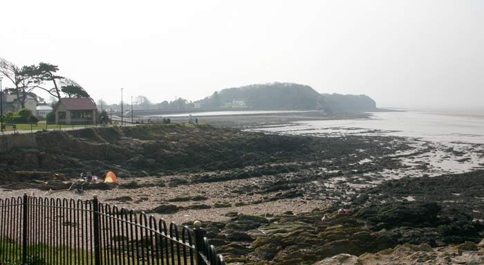
Here we are now in the coastal town of Clevedon North Somerset.
There is not many places to fish high water along the main sea front as it is mostly low cliffs but can grab a couple of hours fishing from the promenade in autumn/winter for whiting/codling and odd dogs pout etc.
But expect a few tackle losses and limited to about 1-1.5 hours flood and 1 hour ebb depending on tides and winds the biggest tides best to maximise fishing time, you may out of sailing season use the slipway for a few hours each side of a neap tide for the same species but expect the odd ray and flounder from the sand bar odd conger and odd smooth hound in their seasons.

Clevedon pier from the promenade.

The clevedon sea front
Looking at some of the rocky headlands on the sea front from the monument ledges
the only other marks along the sea front are the bandstand and monument 2small rocky headlands again the same species expect tackle losses.
The next couple of marks are accessed by the salthouse playing fields you can fish either the cliff end of the marine lake sea wall or go up and over the footpath to the pump house ledges that runs up the woods past the marine lake. the marine lake is best on neaps to mid spring tides as the bigger tides come over and fill it the salt house ledges all tides over high water.

Looking across the marine lake in the background you can see the monument headland and ledges.

Marine lake looking at the pump house and ledges

The salt house ledges behind the marine lake
All of the marks above can be fished over high water except the marine lake by the pump house as the biggest tides come over the wall but the ledges behind it are reasonably safe on all tides except in strong winds!!
Most of the Clevedon sea front marks are only used by the autumn/ winter codling & whiting anglers but it holds a few prospects limited though they are for other species in their seasons.
Cod/coddling/dogfish/whiting/conger/ odd rays & sole with a few odd seasonal visitors.
BAITS all baits work cocktail baits best lug/rag/squid/bluey/makerel/sandeel etc.
RIGS pulley rigs dropper rigs or 2 hook clip down rigs 2/0 hooks upwards.
Local knowledge and beach craft helps for the sea front venues they a few and limited to a few anglers.
The mainstay of the sea fishing is done from Clevedon pier itself, or the main shore fishing from the Clevedon/Kenn/Kingston Seymour sea wall that runs between Clevedon and the Congresbury yeo Estuary appox 3 miles of sea wall.
CLEVEDON PIER
You can fish the pier for a daily fee when open but coincide your trip with a neap tide to maximise your fishing time on the pier a mid day high tide will give you a good 4 hours each side of high water.
But be aware that the pier has its own club so matches are often in autumn/winter held here along with an over 60s match once a month through out the year.
there have been some nice specimen fish caught off the pier see the club gallerys and the pier photos on their sites .
http://www.clevedonpier.com/fishing.htm Prices & times the pier site
http://www.cpsac.co.uk/ Clevedon pier sea angling club site
Joining the pier club allows you to fish it 24/7 all year you get your own key and pass see site for membership.
here are a few pictures of the pier and the fish you could catch.

Anglers fishing Clevedon pier.
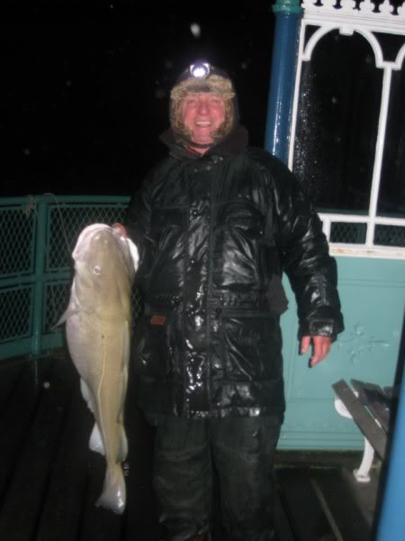
A example of what can be caught off the pier as a club member
SPECIES IN THEIR SEASONS
Cod/codling/congers/whiting/sole/founder/plaice/dogfish/ rays/smooth hounds etc anything can and will turn up so expect the odd surprise visitor.
There is not many places to fish high water along the main sea front as it is mostly low cliffs but can grab a couple of hours fishing from the promenade in autumn/winter for whiting/codling and odd dogs pout etc.
But expect a few tackle losses and limited to about 1-1.5 hours flood and 1 hour ebb depending on tides and winds the biggest tides best to maximise fishing time, you may out of sailing season use the slipway for a few hours each side of a neap tide for the same species but expect the odd ray and flounder from the sand bar odd conger and odd smooth hound in their seasons.
Clevedon pier from the promenade.
The clevedon sea front
Looking at some of the rocky headlands on the sea front from the monument ledges
the only other marks along the sea front are the bandstand and monument 2small rocky headlands again the same species expect tackle losses.
The next couple of marks are accessed by the salthouse playing fields you can fish either the cliff end of the marine lake sea wall or go up and over the footpath to the pump house ledges that runs up the woods past the marine lake. the marine lake is best on neaps to mid spring tides as the bigger tides come over and fill it the salt house ledges all tides over high water.
Looking across the marine lake in the background you can see the monument headland and ledges.
Marine lake looking at the pump house and ledges
The salt house ledges behind the marine lake
All of the marks above can be fished over high water except the marine lake by the pump house as the biggest tides come over the wall but the ledges behind it are reasonably safe on all tides except in strong winds!!
Most of the Clevedon sea front marks are only used by the autumn/ winter codling & whiting anglers but it holds a few prospects limited though they are for other species in their seasons.
Cod/coddling/dogfish/whiting/conger/ odd rays & sole with a few odd seasonal visitors.
BAITS all baits work cocktail baits best lug/rag/squid/bluey/makerel/sandeel etc.
RIGS pulley rigs dropper rigs or 2 hook clip down rigs 2/0 hooks upwards.
Local knowledge and beach craft helps for the sea front venues they a few and limited to a few anglers.
The mainstay of the sea fishing is done from Clevedon pier itself, or the main shore fishing from the Clevedon/Kenn/Kingston Seymour sea wall that runs between Clevedon and the Congresbury yeo Estuary appox 3 miles of sea wall.
CLEVEDON PIER
You can fish the pier for a daily fee when open but coincide your trip with a neap tide to maximise your fishing time on the pier a mid day high tide will give you a good 4 hours each side of high water.
But be aware that the pier has its own club so matches are often in autumn/winter held here along with an over 60s match once a month through out the year.
there have been some nice specimen fish caught off the pier see the club gallerys and the pier photos on their sites .
http://www.clevedonpier.com/fishing.htm Prices & times the pier site
http://www.cpsac.co.uk/ Clevedon pier sea angling club site
Joining the pier club allows you to fish it 24/7 all year you get your own key and pass see site for membership.
here are a few pictures of the pier and the fish you could catch.
Anglers fishing Clevedon pier.
A example of what can be caught off the pier as a club member
SPECIES IN THEIR SEASONS
Cod/codling/congers/whiting/sole/founder/plaice/dogfish/ rays/smooth hounds etc anything can and will turn up so expect the odd surprise visitor.
Admin- Admin Team
- Posts : 440
Join date : 2010-06-21 -
![]()
![]()
KENN SEA WALL FOR RESOURCE
![]() by Admin Tue May 03, 2011 11:00 pm
by Admin Tue May 03, 2011 11:00 pm
Here we proceed from Clevedon to Kingston Seymour along the sea wall that runs from waynes hill Clevedon to the Congresbury Yeo estuary about 3 miles of sea and grass bank sea defences.
Comfortable easy fishing but involves long walks and limited parking and very few access points.
first up the Kenn sea wall
coming from clevedon via old church road

The harbour or Clevedon pill at high tide

The same view at low tide

The gateway from across the kenn sluice gates to the main sea wall

The main Kenn sea wall at low tide
Looking back towards the entrance and clevedon

Looking over toward black rock reefs this is a low water reef we will deal with later.
There are very few access points and parking places for the Kenn part of the sea wall but it is easier to access than the Kingston end .
The main access parking points are old church road there is a car park by the church this will involve along walk along the sea wall and over the river Kenn sea sluice to the main fishing part of the wall travel light or use a trolley or as some locals use a push bike.
For nearer parking access Yeolands Drive and take a right into the Tynings these are a double cul-de-sacs and back onto a recreation field.
PARK TIDY AND DO NOT BLOCK DRIVES!!
A walk across the field to the sea wall along the river bank this will bring you to the sea wall by the sluice gates, go through the gates and walk on until you come out onto the sea wall.
This is a quicker way and safer parking again a trolley would be very useful as you may want to or have to walk a long way.
There are a couple of access points along strode road that involve a walk along a farm track to the sea wall but parking is a premium and can make your car a tempting target for fuel or car thieves!!
Please ensure you take some water proof or wind proof clothing as it can be very exposed all along here and if night fishing ensure you have a good head light and a spare plus spare batteries !!
The main Kenn sea wall is concrete with a rock armour support along most of its length this is a high tide venue depending where you choose to fish as some parts corners are a bit further out and will give you a bit more fishing time mid spring tides to about 11.6 metre W-S-M. scale THE BIGGEST TIDES 12 METRE + often can come over the top in places and push you back to the grass bank that acts as a secondary barrier check the tide lines but some parts of the wall are higher .
We recommend you take a good reccie for your selves or go with some one that knows the wall also do not fish this in strong westerly or north westerly or north winds as they push the tides up further.
Fishing wise you should get about 2 hours each side of high a bit longer depending on your location tide winds and casting ability.
SPECIES
Cod/codling/ bass / rays / conger eels/ silver eels/ flounders/ and odd sole plus the odd seasonal visitor good for mullet all along its length float fishing maggots or maddies.
TACTICS.
for the bigger fish pulley rigs or dropper rigs up & overs long snoods for the rays, or 2-3 hook clip down or flapper rigs for the smaller species and flatties etc
BAITS
All baits work along here but worm cocktails work better lugworm/ragworm/crab/fish baits/ squid / bluey/sand eels on their own or mixed in a cocktails or tipped off with a bit of squid or fish etc.
Comfortable easy fishing but involves long walks and limited parking and very few access points.
first up the Kenn sea wall
coming from clevedon via old church road
The harbour or Clevedon pill at high tide
The same view at low tide
The gateway from across the kenn sluice gates to the main sea wall
The main Kenn sea wall at low tide
Looking back towards the entrance and clevedon
Looking over toward black rock reefs this is a low water reef we will deal with later.
There are very few access points and parking places for the Kenn part of the sea wall but it is easier to access than the Kingston end .
The main access parking points are old church road there is a car park by the church this will involve along walk along the sea wall and over the river Kenn sea sluice to the main fishing part of the wall travel light or use a trolley or as some locals use a push bike.
For nearer parking access Yeolands Drive and take a right into the Tynings these are a double cul-de-sacs and back onto a recreation field.
PARK TIDY AND DO NOT BLOCK DRIVES!!
A walk across the field to the sea wall along the river bank this will bring you to the sea wall by the sluice gates, go through the gates and walk on until you come out onto the sea wall.
This is a quicker way and safer parking again a trolley would be very useful as you may want to or have to walk a long way.
There are a couple of access points along strode road that involve a walk along a farm track to the sea wall but parking is a premium and can make your car a tempting target for fuel or car thieves!!
Please ensure you take some water proof or wind proof clothing as it can be very exposed all along here and if night fishing ensure you have a good head light and a spare plus spare batteries !!
The main Kenn sea wall is concrete with a rock armour support along most of its length this is a high tide venue depending where you choose to fish as some parts corners are a bit further out and will give you a bit more fishing time mid spring tides to about 11.6 metre W-S-M. scale THE BIGGEST TIDES 12 METRE + often can come over the top in places and push you back to the grass bank that acts as a secondary barrier check the tide lines but some parts of the wall are higher .
We recommend you take a good reccie for your selves or go with some one that knows the wall also do not fish this in strong westerly or north westerly or north winds as they push the tides up further.
Fishing wise you should get about 2 hours each side of high a bit longer depending on your location tide winds and casting ability.
SPECIES
Cod/codling/ bass / rays / conger eels/ silver eels/ flounders/ and odd sole plus the odd seasonal visitor good for mullet all along its length float fishing maggots or maddies.
TACTICS.
for the bigger fish pulley rigs or dropper rigs up & overs long snoods for the rays, or 2-3 hook clip down or flapper rigs for the smaller species and flatties etc
BAITS
All baits work along here but worm cocktails work better lugworm/ragworm/crab/fish baits/ squid / bluey/sand eels on their own or mixed in a cocktails or tipped off with a bit of squid or fish etc.
Admin- Admin Team
- Posts : 440
Join date : 2010-06-21 -
![]()
![]()
BLACK ROCK REEFS CLEVEDON FOR RESOURCE
![]() by Admin Tue May 03, 2011 11:03 pm
by Admin Tue May 03, 2011 11:03 pm
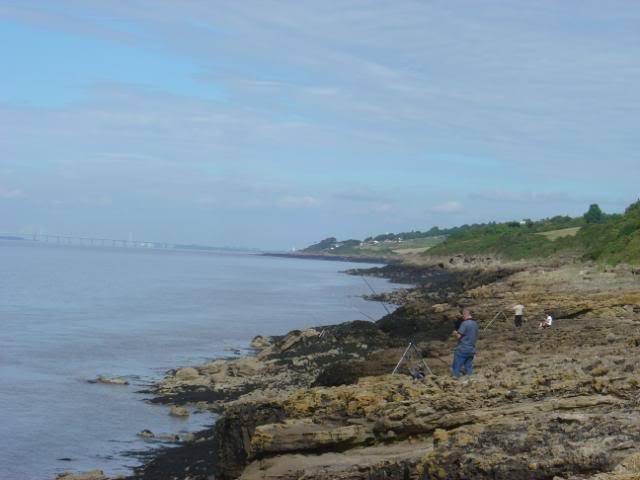
Here we preview black rock reefs Clevedon there is a big danger element which we will disclose later!!
But first we will have a look at the reef that can be accessed from the Kenn Sea Wall this does involve along trek and we advise you travel light one rod is best but you can use 2 the main walk over the reef will be slippery underfoot as the tide retreats exposing the weed and rocks and ledges there will be after a lot of calm weather silt deposits that will fill in a lot of the ledges so be warned they can hide a deep ledge and you may loose your footing and injure yourself!!!
The revealing reef the tide on the ebb now is the time to access it to maximise your fishing.

The upper to middle reef note the weed!!

The lower reef near low tide notice that you are well down over and i can tell you you can not see mud behind the reef where the tide comes in!!!
This is looking at Waynes hill and you can see Clevedon pier in the background
The lower reefs looking towards St Thomases head and sand point in the distance.
NOW THE DANGER !!!
AGAIN A LOOK AT THE FIRST PICTURE BUT LETS REVERSE THE TIDE NOW ON THE FLOOD!!!
Now you see the real danger of black rock reef the tide comes in behind you and if you was still out there you would not see this from the reef till to late!!
So make a good note of this 3 hours after the flood you will not have enough time to get off the reef also allow for an offshore wind and it will push in quicker!!!
So our advice is do not fish this reef alone and fish it with someone that knows the reef and the dangers and do not fish it in the dark, avoid it in strong winds as it holds the tide up and pushes it in quicker!!!!
Having taken a note of the danger of this mark it does offer some good fishing potential and some good fish have been landed here including bass.rays.and odd smooth hounds some good cod and codling along with some good conger eels.
The best times are low water spring tides times do vary according to tide and winds but as a rule the biggest tides will give 3 hours down and 1.5 hours back for safety but if you fish the left hand side of the reef ( sand point side) and fish it it all the way down to low water and fish it back the same way you can keep ahead of the tide with several moves and maybe get another 30-45minutes fishing before you retreat you will also be able to keep an eye on the rear reef access.
The other side of fishing the reef when you come off it you can walk along the wall and reset up to fish the high tide being spring tides so it can give you a double bite of the apple so to speak because by the time you have walked along the wall and set up the tide will be fast approaching and fishable so you may only loose a couple of hours fishing or you could make a day of it fish the morning high have something to eat then go out on the reef fish it down and then fish the evening high tide if you have enough bait and stamina.
Tactics
Big baits bigger hooks pulley pennell rigs or dropper rigs for the reef.
Baits
Whole squid fish baits mackerel,herring, bluey,lugworm,ragworm. sand eel launce crabs single baits or cocktails.
Species
Cod,codling,congers.rays.bass. odd summer species and winter species visitors can be had along with dogfish pout, whiting, silver eels with the odd sole and flattie on the mud banks to the left.
But first we will have a look at the reef that can be accessed from the Kenn Sea Wall this does involve along trek and we advise you travel light one rod is best but you can use 2 the main walk over the reef will be slippery underfoot as the tide retreats exposing the weed and rocks and ledges there will be after a lot of calm weather silt deposits that will fill in a lot of the ledges so be warned they can hide a deep ledge and you may loose your footing and injure yourself!!!
The revealing reef the tide on the ebb now is the time to access it to maximise your fishing.
The upper to middle reef note the weed!!
The lower reef near low tide notice that you are well down over and i can tell you you can not see mud behind the reef where the tide comes in!!!
This is looking at Waynes hill and you can see Clevedon pier in the background
The lower reefs looking towards St Thomases head and sand point in the distance.
NOW THE DANGER !!!
AGAIN A LOOK AT THE FIRST PICTURE BUT LETS REVERSE THE TIDE NOW ON THE FLOOD!!!
Now you see the real danger of black rock reef the tide comes in behind you and if you was still out there you would not see this from the reef till to late!!
So make a good note of this 3 hours after the flood you will not have enough time to get off the reef also allow for an offshore wind and it will push in quicker!!!
So our advice is do not fish this reef alone and fish it with someone that knows the reef and the dangers and do not fish it in the dark, avoid it in strong winds as it holds the tide up and pushes it in quicker!!!!
Having taken a note of the danger of this mark it does offer some good fishing potential and some good fish have been landed here including bass.rays.and odd smooth hounds some good cod and codling along with some good conger eels.
The best times are low water spring tides times do vary according to tide and winds but as a rule the biggest tides will give 3 hours down and 1.5 hours back for safety but if you fish the left hand side of the reef ( sand point side) and fish it it all the way down to low water and fish it back the same way you can keep ahead of the tide with several moves and maybe get another 30-45minutes fishing before you retreat you will also be able to keep an eye on the rear reef access.
The other side of fishing the reef when you come off it you can walk along the wall and reset up to fish the high tide being spring tides so it can give you a double bite of the apple so to speak because by the time you have walked along the wall and set up the tide will be fast approaching and fishable so you may only loose a couple of hours fishing or you could make a day of it fish the morning high have something to eat then go out on the reef fish it down and then fish the evening high tide if you have enough bait and stamina.
Tactics
Big baits bigger hooks pulley pennell rigs or dropper rigs for the reef.
Baits
Whole squid fish baits mackerel,herring, bluey,lugworm,ragworm. sand eel launce crabs single baits or cocktails.
Species
Cod,codling,congers.rays.bass. odd summer species and winter species visitors can be had along with dogfish pout, whiting, silver eels with the odd sole and flattie on the mud banks to the left.
Admin- Admin Team
- Posts : 440
Join date : 2010-06-21 -
![]()
![]()
KINGSTON SEYMOUR SEA WALL FOR RESOURCE
![]() by Admin Tue May 03, 2011 11:05 pm
by Admin Tue May 03, 2011 11:05 pm
Here we come to Kingston Seymour sea wall between Clevedon and Sand point.

This part of the wall is accessed via middle lane Kingston Seymour parking in the lane by channel farm.
There is a track that runs down beside channel farm and the bungalow this runs for about 1/2 a mile to the sea wall
the higher bit of the wall is to your right see photo above and the lower part runs to your left towards the Yeo estuary, this is backed up by a grass bunde bank old sea defence on the biger tides a 12.5 metre and above w-s-m tidal scale the sea comes over the lower sea wall and goes back to the grass bank take a note of the tidal lines here.
Except on the biggest tides and with strong winds behind them the right hand side is reasonably safe in places as they are high enough to fish from in comfort it is protected by rock armour defence see photo above.
Again travel light or take a trolley or push bike as the locals use to access further marks along the wall fishing is mainly 2 hours each side of high water spring tides dependant on tides and wind.
SPECIES
cod ,codling, flatties, conger eels,silver eels, bass,thornback rays, whiting and pout with odd sole.
TACTICS
2-3 hook match rigs single hook pulley rigs or dropper rigs for rays and pulley pennel rigs for the cod and bigger fish congers etc.
BAITS
All baits work on their own or in cocktails worm baits in general big lugworm baits for the cod in autumn/winter
lug rag cocktails tipped with squid.fish baits etc for geneal fishing crab sandeel for bass and rays and mackerel for the conger eels expect the odd dogfish on fish baits.
Admin- Admin Team
- Posts : 440
Join date : 2010-06-21 -
![]()
![]()
ST THOMASES HEAD TO MIDDLE HOPE BAY
![]() by Admin Wed Nov 06, 2013 10:53 am
by Admin Wed Nov 06, 2013 10:53 am
ST THOMAS"S HEAD OR THE ADMIRALTY END OF SAND POINT MARKS THE CLEVEDON END OF SAND POINT WHERE THE RIVER BANWELL RUNS INTO THE SEA.
THIS IS A TOP RAY AND CODDLING MARK ALONG WITH SMOOTH HOUNDS AND BASS IN SEASON WHITING AND DOGFISH POUT AND COD SOME BETTER ONES ARE CAUGHT HERE AND ALONG THE SANDBANKS BACK TOWARDS MIDDLE HOPE BAY.
FROM THE REEFS AT THE END ON MEDIUM SPRING TIDES YOU ARE FISHING INTO DEEP WATER CHANNELS OVER TUBE WORM BEDS ON THE BIGGEST SPRING TIDES 12 METRE PLUS ON W-S-M SCALE THE REEFS EXPOSE SO YOU CANT FISH THE END REEF OVER LOW BUT BACK TOWARDS THE SLIPWAY FROM THE EX- MILITARY BASE YOU CAN.
PST THE CRADLE LOCALS REFER TO THE EXPLOSIVE DETONATION RACK YOU COME ONTO A LONG LARGE SANDBAR THAT TURNS INTO MUD AS IT RUNS INTO MIDDLEHOPE BAY .
THERE IS SOFT PATCHES AND THERE IS A LOT OF ORDINANCE DEBRIS ALL ALONG HERE IT SHELVES OF QUITE STEEPLY ON THE BIGGEST TIDES AND YOU ARE FISHING INTO THE MAIN INSIDE CHANNEL THAT RUNS OUT OF WOODSPRING BAY.
THE PICTURES BELOW WILL SHOW YOU WHAT YOU ARE FISHING INTO

THIS PICTURE ABOVE IS THE VIEW FROM THE TOP OF THE STYLE FROM WOODSPRING NATIONAL TRUST CAR PARK LOOKING ALONG THE CREEK THAT RUNS PAST THE ADMIRALTY PIER IN THE DISTANCE IT IS A LEVEL BUT MUDDY WALK ALONG THE GRASS UNDER THE PIER THEN A WALK OVER ROCKS TO THE POINT REEFS THAT MARKS THE ESTUARY OF THE BANWELL RIVER THE CREEK EMPTIES RIGHT OUT ON BIG SPING TIDE LOWS DO NOT ATTEMPT TO CROSS IT !!!!

ABOVE IS AN OVERVEIW OF THE HEADLAND POINT AND BAY UNDER THE EX-MILITARY BASE .
ON THE FAR RIGHT IS THE REEF IN THE DISTANCE IS SWAINS HILL AND CLEVEDON THE MIDDLE BANKS ARE NOW EXPOSING IN THIS PICTURE REVEALING THE INNER CHANNEL.
IN THE MIDDLE BEHIND THE ANGLERS IS THE SLIPWAY THE MILITARY USED TO BRING DOWN THE ORDINANCE FOR EXPLOSIVE DISPOSAL AT LOW TIDE AND EXPLODING ON HIGH TIDE THE RED FLAG FLIES WHEN EXPLODING YOU WILL BE MOVED OFF IF THIS IS THE CASE BUT SINCE PRIVATE CONTRACTING THERE HAS BEEN NO DISPOSALS OVER THE LAST FEW YEARS BUT BE AWARE IT IS PRIVATE PROPERTY AND WELL GUARDED YOU WONT SEE THEM BUT THEY SEE YOU PLENTY OF CAMERAS TO PROVE THAT POINT!!
IN THE CENTRE IS THE SAND BAY THIS HAS A STEEP DROP OFF INTO STRONG TIDES DO NOT ATTEMPT TO WADE OUT TO CAST YOU DO NOT NEED TO CAST FAR HERE SO DO NOT RISK IT !!
TO THE LEFT JUST OUT OF SHOT IS THE CRADLE AS WE CALL IT A BIG METAL STRUCTURE AND A SMALLER ONE THEY USE TO SECURE THE ORDINANCE FOR DISPOSAL!!!

THE PICTURE ABOVE IS A SHOT OF THE SAND BANK THAT RUNS TOWARDS MIDDLE HOPE BAY THERE IS SOFT PATCHES AND THE ODD MUD PATCH IT IS SOFT ON THE INITIAL DROP BUT AS THE TIDE DROPS RIGHT OFF IT HARDENS BUT BEWARE MOVE ABOUT A BIT AND DO NOT WADE OUT INTO THE WATER AGAIN IT HIDES A STEEP DROP OFF. INTO DEEP WATER AND STRONG CURRENTS.
YOU MAY FISH THIS DOWN AS SOON AS IT EXPOSES FROM THE REEFS TO LOW WATER AND RETREAT UP ONTO THE REEFS FOR A FINAL FISH THEN PACK UP AND MOVE OFF ENSURE YOU HAVE A SAFE RETREAT
ON NEAP TIDES AND IF YOU ARE A GOOD CASTER YOU CAN FISH THIS END OVER HIGH TIDE EXPECT SOME LOSSES AND MORE IF YOU FISH IT TO FAR DOWN BUT IT CAN BE FISHED AND PRODUCES SOME GOOD RESULTS ON NEAPS ALSO A GOOD LOW WATER OVER MID SPRINGS AS YOU FISH FROM THE EDGE OF THE REEFS INTO DEEP WATER AND CLEANISH SAND GIVES YOU A BETTER CHANCE OF LANDING THAT BIG FISH.
THERE IS A LOT OF SHRAPNEL OUT THERE SO EXPECT TO LOSE THE ODD RIG/FISH CHECK YOUR LINES REGULARY AND KEEP YOUR ROD TIPS HIGH !!
SEVERAL HOT SPOTS FOR GOOD RAY FISHING EXPECT DOUBLE FIGURE RAYS TO POP UP NOW AND THEN GOOD CONGERS TO 20LB PLUS HERE AS WELL GOOD BASS TO LOW DOUBLES AND COD TO MID DOUBLES ALONG WITH THE ODD GOOD HOUND IN THEIR SEASONS THE COD FISHING CAN START HERE AS EARLY AS THE END OF JULY THE BEST MONTHS AUGUST TO OCTOBER BEFORE THE SPRATS ARRIVE !!
NO MESSING ABOUT HERE IF YOU USE 2 HOOK CLIP DOWNS USE A MINIMUM 2/0 HOOK LIKE A VARIVAS BIG MOUTH EXTRA AND USE BIG HOOK PENNELS 4/0 UP TO 8/0 FOR THE CONGERS AND RAYS 4/0 S-6/0 S PULLEY RIGS OR DROPPER RIGS FOE THE COD THEY ARE THE MAIN STAY RIGS FOR HERE A GOOD 70LB OR 80LB MAIN RIG BODY AND 40LB PLUS SNOODS ARE A RULE OF THUMB HERE TO NAIL YOUR BAITS HARD ON THE BOTTOM
STRONG HOOKS LIKE VARIVAS BIG MOUTH EXTRAS OR SAKUMA MANTA EXTRAS EXPECT SOME TACKLE LOSSES AND TAKE PLENTY OF WEIGHTS 6 OZ AS A RULE 5 WILL COPE BUT LET YOUR LINE RUN OUT INTO A BOW LIKE UPTIDEING FROM A BOAT.
BAITS PEELER IS TOP SUMMER AUTUMN BAIT ALONG WITH LUG SQUID AND FISH BAITS LARGE SANDEELS FOR THE RAYS AND TAKE PLENTY OF BAIT AND PILE IT ON THESE STRONG CURRENTS SOON WASH IT OUT 10-15 MINUTE TO REBAIT AS THE SCENT WILL BE WASHED OUT IN THAT TIME PLUS THE CRABS WILL HAVE STRIPPED IT OFF!!
NO SKIMPING ON BAIT HERE AS YOU WONT CATCH ANYTHING BIG BAITS BIG HOOKS AND STRONG RIG BODIES /SNOODS THE ORDER OF THE DAY ANYTHING BELOW 30LB SNOODS WILL TANGLE LIKE A BALL OF WOOL IN THESE STRONG CURRENTS !!
YOU CAN GET DEPENDANT ON TIDES AND YOUR KNOWLEDGE /BEACHCRAFT OF THIS MARK UP TO 6 HOURS FISHING 3 DOWN 3 BACK BUT ON SOME TIDES AND YOU GET THERE EARLY ENOUGH FOR THE REEFS TO BE ABOUT TO REVEAL THERE ENDS 4 DOWN PLUS 3 BACK AND ON MID SPRINGS ABOUT 3 DOWN 3 BACK BUT IS STIFF WESTERLY OR ANY NORTH WINDS EXPECT A LOT LESS TIME AND ABOUT 2 HOURS BACK BECUASE OF THE PUSH. AS STATED DEPENDS ON HEIGHT OF TIDES AND WINDS BUT YOU CAN WITH EXPERIENCE MILK THAT BIT EXTRA FROM THE MARK AT CERTAIN POINTS ALONG THE SAND BAR THE POINT IS A 3 DOWN 2.5 BACK AFTER THAT YOU LOSE GEAR BIG TIME COMING OVER THE REEFS!!!!
http://maps.google.com/maps/ms?ie=UTF8&hl=en&msa=0&msid=105893482469178345673.000490adddfe3a4567019&t=h&ll=51.096623,-1.724854&spn=3.670876,7.064209&z=7
THIS IS A TOP RAY AND CODDLING MARK ALONG WITH SMOOTH HOUNDS AND BASS IN SEASON WHITING AND DOGFISH POUT AND COD SOME BETTER ONES ARE CAUGHT HERE AND ALONG THE SANDBANKS BACK TOWARDS MIDDLE HOPE BAY.
FROM THE REEFS AT THE END ON MEDIUM SPRING TIDES YOU ARE FISHING INTO DEEP WATER CHANNELS OVER TUBE WORM BEDS ON THE BIGGEST SPRING TIDES 12 METRE PLUS ON W-S-M SCALE THE REEFS EXPOSE SO YOU CANT FISH THE END REEF OVER LOW BUT BACK TOWARDS THE SLIPWAY FROM THE EX- MILITARY BASE YOU CAN.
PST THE CRADLE LOCALS REFER TO THE EXPLOSIVE DETONATION RACK YOU COME ONTO A LONG LARGE SANDBAR THAT TURNS INTO MUD AS IT RUNS INTO MIDDLEHOPE BAY .
THERE IS SOFT PATCHES AND THERE IS A LOT OF ORDINANCE DEBRIS ALL ALONG HERE IT SHELVES OF QUITE STEEPLY ON THE BIGGEST TIDES AND YOU ARE FISHING INTO THE MAIN INSIDE CHANNEL THAT RUNS OUT OF WOODSPRING BAY.
THE PICTURES BELOW WILL SHOW YOU WHAT YOU ARE FISHING INTO
THIS PICTURE ABOVE IS THE VIEW FROM THE TOP OF THE STYLE FROM WOODSPRING NATIONAL TRUST CAR PARK LOOKING ALONG THE CREEK THAT RUNS PAST THE ADMIRALTY PIER IN THE DISTANCE IT IS A LEVEL BUT MUDDY WALK ALONG THE GRASS UNDER THE PIER THEN A WALK OVER ROCKS TO THE POINT REEFS THAT MARKS THE ESTUARY OF THE BANWELL RIVER THE CREEK EMPTIES RIGHT OUT ON BIG SPING TIDE LOWS DO NOT ATTEMPT TO CROSS IT !!!!
ABOVE IS AN OVERVEIW OF THE HEADLAND POINT AND BAY UNDER THE EX-MILITARY BASE .
ON THE FAR RIGHT IS THE REEF IN THE DISTANCE IS SWAINS HILL AND CLEVEDON THE MIDDLE BANKS ARE NOW EXPOSING IN THIS PICTURE REVEALING THE INNER CHANNEL.
IN THE MIDDLE BEHIND THE ANGLERS IS THE SLIPWAY THE MILITARY USED TO BRING DOWN THE ORDINANCE FOR EXPLOSIVE DISPOSAL AT LOW TIDE AND EXPLODING ON HIGH TIDE THE RED FLAG FLIES WHEN EXPLODING YOU WILL BE MOVED OFF IF THIS IS THE CASE BUT SINCE PRIVATE CONTRACTING THERE HAS BEEN NO DISPOSALS OVER THE LAST FEW YEARS BUT BE AWARE IT IS PRIVATE PROPERTY AND WELL GUARDED YOU WONT SEE THEM BUT THEY SEE YOU PLENTY OF CAMERAS TO PROVE THAT POINT!!
IN THE CENTRE IS THE SAND BAY THIS HAS A STEEP DROP OFF INTO STRONG TIDES DO NOT ATTEMPT TO WADE OUT TO CAST YOU DO NOT NEED TO CAST FAR HERE SO DO NOT RISK IT !!
TO THE LEFT JUST OUT OF SHOT IS THE CRADLE AS WE CALL IT A BIG METAL STRUCTURE AND A SMALLER ONE THEY USE TO SECURE THE ORDINANCE FOR DISPOSAL!!!
THE PICTURE ABOVE IS A SHOT OF THE SAND BANK THAT RUNS TOWARDS MIDDLE HOPE BAY THERE IS SOFT PATCHES AND THE ODD MUD PATCH IT IS SOFT ON THE INITIAL DROP BUT AS THE TIDE DROPS RIGHT OFF IT HARDENS BUT BEWARE MOVE ABOUT A BIT AND DO NOT WADE OUT INTO THE WATER AGAIN IT HIDES A STEEP DROP OFF. INTO DEEP WATER AND STRONG CURRENTS.
YOU MAY FISH THIS DOWN AS SOON AS IT EXPOSES FROM THE REEFS TO LOW WATER AND RETREAT UP ONTO THE REEFS FOR A FINAL FISH THEN PACK UP AND MOVE OFF ENSURE YOU HAVE A SAFE RETREAT
ON NEAP TIDES AND IF YOU ARE A GOOD CASTER YOU CAN FISH THIS END OVER HIGH TIDE EXPECT SOME LOSSES AND MORE IF YOU FISH IT TO FAR DOWN BUT IT CAN BE FISHED AND PRODUCES SOME GOOD RESULTS ON NEAPS ALSO A GOOD LOW WATER OVER MID SPRINGS AS YOU FISH FROM THE EDGE OF THE REEFS INTO DEEP WATER AND CLEANISH SAND GIVES YOU A BETTER CHANCE OF LANDING THAT BIG FISH.
THERE IS A LOT OF SHRAPNEL OUT THERE SO EXPECT TO LOSE THE ODD RIG/FISH CHECK YOUR LINES REGULARY AND KEEP YOUR ROD TIPS HIGH !!
SEVERAL HOT SPOTS FOR GOOD RAY FISHING EXPECT DOUBLE FIGURE RAYS TO POP UP NOW AND THEN GOOD CONGERS TO 20LB PLUS HERE AS WELL GOOD BASS TO LOW DOUBLES AND COD TO MID DOUBLES ALONG WITH THE ODD GOOD HOUND IN THEIR SEASONS THE COD FISHING CAN START HERE AS EARLY AS THE END OF JULY THE BEST MONTHS AUGUST TO OCTOBER BEFORE THE SPRATS ARRIVE !!
NO MESSING ABOUT HERE IF YOU USE 2 HOOK CLIP DOWNS USE A MINIMUM 2/0 HOOK LIKE A VARIVAS BIG MOUTH EXTRA AND USE BIG HOOK PENNELS 4/0 UP TO 8/0 FOR THE CONGERS AND RAYS 4/0 S-6/0 S PULLEY RIGS OR DROPPER RIGS FOE THE COD THEY ARE THE MAIN STAY RIGS FOR HERE A GOOD 70LB OR 80LB MAIN RIG BODY AND 40LB PLUS SNOODS ARE A RULE OF THUMB HERE TO NAIL YOUR BAITS HARD ON THE BOTTOM
STRONG HOOKS LIKE VARIVAS BIG MOUTH EXTRAS OR SAKUMA MANTA EXTRAS EXPECT SOME TACKLE LOSSES AND TAKE PLENTY OF WEIGHTS 6 OZ AS A RULE 5 WILL COPE BUT LET YOUR LINE RUN OUT INTO A BOW LIKE UPTIDEING FROM A BOAT.
BAITS PEELER IS TOP SUMMER AUTUMN BAIT ALONG WITH LUG SQUID AND FISH BAITS LARGE SANDEELS FOR THE RAYS AND TAKE PLENTY OF BAIT AND PILE IT ON THESE STRONG CURRENTS SOON WASH IT OUT 10-15 MINUTE TO REBAIT AS THE SCENT WILL BE WASHED OUT IN THAT TIME PLUS THE CRABS WILL HAVE STRIPPED IT OFF!!
NO SKIMPING ON BAIT HERE AS YOU WONT CATCH ANYTHING BIG BAITS BIG HOOKS AND STRONG RIG BODIES /SNOODS THE ORDER OF THE DAY ANYTHING BELOW 30LB SNOODS WILL TANGLE LIKE A BALL OF WOOL IN THESE STRONG CURRENTS !!
YOU CAN GET DEPENDANT ON TIDES AND YOUR KNOWLEDGE /BEACHCRAFT OF THIS MARK UP TO 6 HOURS FISHING 3 DOWN 3 BACK BUT ON SOME TIDES AND YOU GET THERE EARLY ENOUGH FOR THE REEFS TO BE ABOUT TO REVEAL THERE ENDS 4 DOWN PLUS 3 BACK AND ON MID SPRINGS ABOUT 3 DOWN 3 BACK BUT IS STIFF WESTERLY OR ANY NORTH WINDS EXPECT A LOT LESS TIME AND ABOUT 2 HOURS BACK BECUASE OF THE PUSH. AS STATED DEPENDS ON HEIGHT OF TIDES AND WINDS BUT YOU CAN WITH EXPERIENCE MILK THAT BIT EXTRA FROM THE MARK AT CERTAIN POINTS ALONG THE SAND BAR THE POINT IS A 3 DOWN 2.5 BACK AFTER THAT YOU LOSE GEAR BIG TIME COMING OVER THE REEFS!!!!
http://maps.google.com/maps/ms?ie=UTF8&hl=en&msa=0&msid=105893482469178345673.000490adddfe3a4567019&t=h&ll=51.096623,-1.724854&spn=3.670876,7.064209&z=7
Admin- Admin Team
- Posts : 440
Join date : 2010-06-21 -
![]()
![]()
Sponsored content
![]()
![]()
![]()

 Similar topics
» FISHING MARKS AND INFORMATION ABOUT IRELAND
» BRISTOL CHANNEL FISHING & INFORMATION YOU-TUBE VIDEO LINKS
» ISLANDS OF THE BRISTOL CHANNEL INFORMATION LINKS FOR RESOURCE
» GOOGLE MAPS OF FISHING MARKS AROUND THE UK LINKS FOR YOU TO RESOURCE
» PIERS AROUND THE U.K & ISLANDS OF THE BRISTOL CHANNEL
» BRISTOL CHANNEL FISHING & INFORMATION YOU-TUBE VIDEO LINKS
» ISLANDS OF THE BRISTOL CHANNEL INFORMATION LINKS FOR RESOURCE
» GOOGLE MAPS OF FISHING MARKS AROUND THE UK LINKS FOR YOU TO RESOURCE
» PIERS AROUND THE U.K & ISLANDS OF THE BRISTOL CHANNEL
ADDICTION ANGLING RESOURCES & INFORMATION SITE :: GOOGLE MAPS & FISHING MARKS AROUND THE UK RESOURCES LIST
Page 1 of 1
Permissions in this forum:
You cannot reply to topics in this forum|
|
|